
Nayagarh is a gorgeous town between two hills. So many locals enjoy this place and have often referred to tourists to visit this haven but most visitors never get past them to see what else the district is quietly holding onto. Beyond the town itself, you see various riverside ghats all round the outers, old shrines at the point where both rivers meet, and a huge picnic ground that does not make it to the itinerary.
Rukhi & Balaram Hills
Rukhi and Balaram hills are the two hills in Nayagarh that basically surround the beautiful places around. The hills of Rukhi stand to the south of the town and the hills of Balaram stand to the north. They are not mere ornaments that add to the beauty of this place, there are the protectors of this place and so much more than that. During the 1999 cyclone of Odisha, this cyclone tore through the state, these two hills are made sure to protect the town of Nayagarh, not fully but they definitely softened the blow which made things quite manageable during this time.
There’s an older story attached to the hills of Rukhi and Balaram. According to local legend, Baghel Singh, the ninth king of the ruling dynasty, was out hunting sometime between 1480 and 1510 in the stretch between Rukhi and Balaram, when he witnessed something strange, a rabbit holding its own against a dog. He took it as a sign of the land’s strength, and that moment is reportedly why Nayagarh picked up the nickname “Baghua Nayagarh”, which roughly translates to valorous Nayagarh. Whether or not the rabbit story holds up to scrutiny, the hills themselves are real enough, and they’re still what gives the town its particular shape and skyline. They are what makes this town beautiful, unique and strong.
Panchupaili Pragana
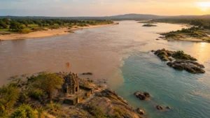
Panchupaili Pragana is situated about 55 km out from Nayagarh town. Now Panchupaili Pragana isn’t the kind of place that shows up on a quick search, if you’re searching for places to explore here but I think that’s part of its appeal. It sits right where the Mahanadi meets another river, and that itself has made it a spot worth visiting. I have always had a thing for water bodies but where two rivers meet or water bodies meet, that’s cherry on the pie. Moreover there are approximately three shrines that sit within the area, Sri Gupteswar Mahadev, Sri Sri Navagunjara Jiu, and a temple to Goddess Kalapat Thakurani, each pulling in a few local devotees everyday rather than tour buses.
It’s less a single destination than a cluster, really, rivers, rock, and old worship sites all sitting close enough together to explore in one unhurried visit. Given the distance from Nayagarh town, this isn’t somewhere you’d casually swing by, it’s worth planning as its own half-day trip, ideally combined with other stops further out in that direction.
Mahanadi Riverside Spots
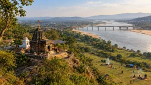
The Mahanadi runs through a good stretch of this district, and a few spots along its banks have quietly become go-to picnic grounds over the years. Gokulananda Tourism Center, near Sidhamula village, is probably the best known of these, built around a temple sitting right on top of a hill overlooking the river. The temple itself was founded by Swami Ram Laxman Dash Maharaja, and the view from up there, river winding below, forested hillside all around, is genuinely one of the better panoramas in the district. You get the same view, slightly different angle, from Sidhamula bridge nearby if the climb isn’t appealing.
What actually makes Gokulananda work as a picnic spot though is the stretch of flat ground at the base of the hill, nearly a kilometre of it, green and open, right along the riverbank. Families use it for cooking, kids run around playing games, and the whole place gets genuinely busy through the winter months, October through March specifically, when the weather actually cooperates. It’s also close enough to Kantilo and the Nilamadhav Temple that pairing the two into a single day trip makes a lot of sense if temple history interests you alongside the scenery.
Best Picnic Locations
Beyond the Mahanadi itself, Nayagarh’s picnic map is mostly built around dams and waterfalls, small irrigation projects that have, almost incidentally, turned into some of the district’s most popular weekend spots. Kuanria Dam near Dasapalla tops most local lists, hills on either side, a deer park next door, boating when conditions allow. Panipoila Dam, just 10 km from Nayagarh town itself, is a smaller, quieter alternative, fed by water flowing down from Rajgiri Waterfall and Ghantali Hill, tucked into the Khandapada forest range.
A handful of waterfalls round out the picture too, Ratnaganda near Dasapalla, Rajgiri, Srabani, Godipalli, each one drawing a steady winter crowd without ever feeling overrun the way bigger state attractions do. Harabhangi Reservoir near Ranapur and Sunamuhin Dam add a couple more water-based options if you’re specifically chasing that combination of hills, water, and quiet. None of these individually demand a dedicated trip, but strung together, they make for a solid few days of exploring if you’re willing to drive between them.
Winter really is the season for all of this, October through February across the board, when the heat has eased off and the water levels at most of these dams and falls are still reasonable. Showing up in peak summer tends to mean dry riverbeds and a lot less reason to make the trip.
Frequently Asked Questions
What are the two hills flanking Nayagarh town called?
Rukhi Hill to the south and Balaram Hill to the north, both credited with helping shield the town from the worst effects of the 1999 Odisha cyclone.
How far is Panchupaili Pragana from Nayagarh town?
Roughly 55 km, making it best suited as its own half-day trip rather than a quick stop combined with closer attractions.
Which is the best riverside picnic spot near Nayagarh?
Gokulananda Tourism Center at Sidhamula village, with its hilltop temple and flat riverside ground, is generally considered the most popular Mahanadi-side picnic spot in the district.
What is the best time of year to visit these hills and picnic spots?
October through February, when cooler weather and better water levels at the dams and waterfalls make the visit far more enjoyable than during peak summer.

